By : Chha


As mention in my previous post Cambodia - Tips on Visiting Siem Reap. There is 3 tour available here in Siem Reap, so for my first day in Siem Reap, i did the Big Circuit tour, the reason is because i arrived at Siem Reap airport at about 8.00 am in the morning and i was told that the Small Circuit which include visit to the famous Angkor Wat has an amazing sun rise view, so i reserve that for day 2.
- Prasat Kravan

My first stop for today is at Prasat Kraven. Prasat Kravan [Khmer: ប្រាសាទក្រវាន់] is a small 10th century temple consisting of five reddish brick towers on a common terrace located at south of the artificial lake or baray called Srah Srang. Prasat Kravan is the modern name in Khmer which means artabotrys odoratissimus temple. The temple was dedicated to Vishnu in 921 CE according to an inscription on doorjambs (Source).


GPS Coordinate :
13.419760, 103.899788
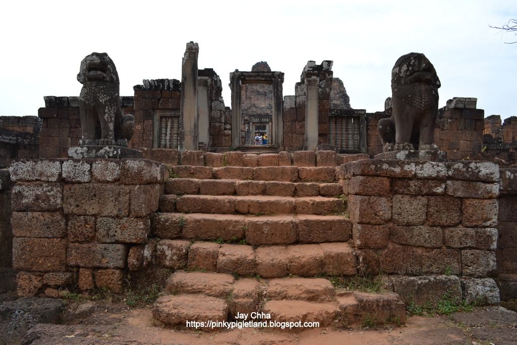
- Srah Srang

Srah Srang [Khmer: ស្រះស្រង់] is a baray or reservoir at Siem Reap, Cambodia which is located south of the East Baray and east of Banteay Kdei (Source). This is the place where the king Jayavarman VII used to take a bath in. Well even the name means royal bath. It has a platform with lions, dragons, and garudas. Some tourist like to come here for sunrise and sunset. Since the embarkation terrace has recently been restored it has now become a place to watch the sunrise (from the embarkation terrace) and sunset (from the East side of the Srah) with a very nice reflection of the sun in the waters (Source).


GPS Coordinate :
13.430525, 103.903226
- Banteay Kdei

Directly just across the street from Srah Srang is where Banteay Kdei is located. Banteay Kdei [Khmer: ប្រាសាទបន្ទាយក្តី] which mean 'A Citadel of Chambers' or also known as 'Citadel of Monks cells' is a Buddhist temple. I was told by my tuk-tuk driver that Banteay Kdei was once used as a place for monk to learn Buddhism and only the best and most brilliant students are being sent here to study, consider it like a school for young monk. The Srah Srang which is directly opposite to Banteay Kdei is where the temple used to gets its source of water from but now no longer the case.


Banteay Kdei is a big place and it takes me around 1 hour plus to finish visit the place and slowly take photo of the amazing architecture of Banteay Kdei.
GPS Coordinate :
13.429938, 103.898040
- Pre Rup

Pre Rup [Khmer: ប្រាសាទប្រែរូប] is a Hindu temple and i was told by my tuk-tuk driver that it used to be a tomb. It is a temple mountain of combined brick, laterite and sandstone construction. The temple’s name is a comparatively modern one meaning 'turn the body'. This reflects the common belief among Cambodians that funerals were conducted at the temple with the ashes of the body being ritually rotated in different directions as the service progressed (Source).


I find the construction of Pre Rup is slightly different from those temple i have seen so far. Because of the location of Pre Rup, this place is said to be a good place to view sunset as well.
GPS Coordinate :
13.434974, 103.920575
- East Mebon

The East Mebon [Khmer: ប្រាសាទមេបុណ្យខាងកើត] is a 10th Century temple which is built during the reign of King Rajendravarman, it stands on what was an artificial island at the center of the now dry East Baray reservoir (Source). It is said that The East Mebon was once only accessible by boat. I was also told that here is where the locals used to come to pray for rain during drought season to help them grow their crops. Tourist looking out from the upper level today are left to imagine the vast expanses of water that formerly surrounded the temple. Four landing stages at the base give reminder that the temple was once reached by boat (Source).


GPS Coordinate :
13.446721, 103.920006
- Ta Som


Ta Som [Khmer: ប្រាសាទតាសោម] is a small temple located north east of Angkor Thom and just east of Neak Pean. The King dedicated the temple to his father Dharanindravarman II (Paramanishkalapada) who was King of the Khmer Empire from 1150 to 1160. The temple consists of a single shrine located on one level and surrounded by enclosure laterite walls. Like the nearby Preah Khan and Ta Prohm the temple was left largely unrestored, with numerous trees and other vegetation growing among the ruins. In 1998, the World Monuments Fund (WMF) added the temple to their restoration program and began work to stabilise the structure to make it safer for visitors (Source).


I like to see all these wall relief around the temple, it is unique and it makes the temple looks stunning !


If you are here visiting Ta Som, try walk until the end of the temple and you will see the back entrance with big tree surrounding it. This tree seems to grow around the entrance wall, looks kinda awesome.
GPS Coordinate :
13.464618, 103.912972
- Neak Pean

Neak Pean is a very special place i must say, the walk way leading towards Neak Pean is soothing and calm for me me, haha ! I like the view here.


Neak Pean or also known as Neak Poan [Khmer: ប្រាសាទនាគព័ន្ធ] is an artificial island with a Buddhist temple on a circular island in Jayatataka Baray which was associated with Preah Khan temple built during the reign of King Jayavarman VII is the 'Mebon' of the Preah Khan baray, the 'Jayatataka' of the inscription. Some historians believe that Neak Pean represents Anavatapta, a mythical lake in the Himalayas whose waters are thought to cure all illness (Source), therefore it is said that last time people used to come here for the water to cure illness.

GPS Coordinate :
13.463350, 103.894783
- Preah Khan

Preah Khan [Khmer: ប្រាសាទព្រះខ័ន] which also mean 'Royal Sword'. Built in the 12th century for King Jayavarman VII to honor his father. Preah Khan was the centre of a substantial organisation with almost 100,000 officials and servants. The temple is flat in design, with a basic plan of successive rectangular galleries around a Buddhist sanctuary complicated by Hindu satellite temples and numerous later additions (Source).

I like how the bridge leading to the entrance of Preah Khan is designed. If you are able to look from far which is what my photo above is not showing, haha ! The bridge have two side if you are standing in the middle of it facing the entrance. There is the right side with statue of demons holding a body of a dragon while on the left side is having statue of gods holding a body of a dragon too. God and demons symbolize the good and the bad in this world. While the dragon is used as a bond to tie up the river or lake around the temple, meaning to hold the water together. Fascinating right ? And the photo i had above is the one showing the gods holding the dragon.


GPS Coordinate :
13.461926, 103.871873

Day 1 - Siem Reap - Big Circuit Route
Visited : December 2017
Posted Date : 10 January 2018
Posted Time : 10.32 pm


Comments
Post a Comment